Lake and surround terrain
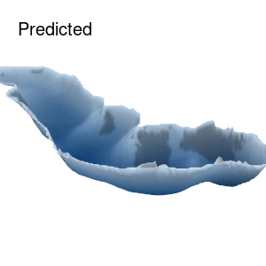
Novel methods for predicting lake bathymetry
Lake size and shape are important descriptors of lake functioning, mapping lake depths (the lake bathymetry) are essential for investigations in aquatic habitats. However, collecting lake bathymetry data can be cumbersome and time-consuming. Depending on the region and origin of lakes, lake bathymetry is expected to be related to the topography of the surrounding terrain. In this project, I investigate how a deep learning model can be used to predict lake bathymetry on using surrounding terrain as input.
Results show that prediction can be drastically improved using deep learning both in terms of accuracy and realism of the resulting bathymetry maps.
Example of ground truth and predicted lake bathymetry (Lake Almind)