 Catchment web map application
Lake catchments
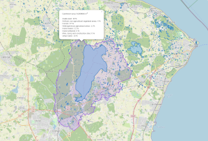
Knowing the ‘topographical catchment area’ (equivalent to the term watershed, upslope area, basin, etc.) for any lake is very useful when considering lake water quality or potential sources of pollution. Catchment delineation can be done using a wealth of software (link to a post on this). The process might however slow down when processing many lakes or using high-resolution digital elevation models (DEMs). Therefore, it is convenient to have these catchments delineated up-front.
Catchment delineation at scale
The publicly available high-resolution DEMs provide a good foundation for delineating high-quality catchments but their size alone might make it a challenge. Delineating a set of coastal drainage basins provides a way to divide-and-conquer each drainage basin and its lakes. This, combined with efficient algorithms, enables the delineation of all Danish lakes without relying on high-performance computing resources.
The data product could be a useful tool in any project. I have wrapped the this into a Shiny app showing characteristics for lakes and catchments. See also the associated paper on the prediction of water quality characteristics for Danish lakes.